|
|
 |
Knowledge Is Key
For Intelligent Decisions
Satellite Logic is a leading,
authoritative source of information in
the Satellite Industry. Located in the
heart of the Silicon Valley, Satellite
Logic provides one of the most
valuable and comprehensive
knowledge bases on the Satellite
market! This is a primary Worldwide
information center which enables our
clients to analyze, evaluate, inquire
and select their best tailored
solutions. Our company sets the
industry standards for targeted
buying leads, reflecting a dramatic
advance over traditional marketing
solutions.
|
|
|
 |
 |
|
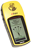
Garmin eTrex H
If you're on a budget or if you don't want an expensive handheld GPS unit the Garmin eTrex H is a great value. Its high-sensitivity signal processor gets excellent satellite reception, even in dense woods or between tall buildings. People like the eTrex H for being lightweight, tough, water-resistant and easy on batteries. The eTrex H cuts costs by skipping two major features: mapping and a color screen. The eTrex H cannot accept or read actual maps. Instead, it displays a graphic showing your track and any waypoints you have entered.
With a monochrome LCD, no built-in maps and only basic GPS guidance, the Garmin eTrex H isnt for hiking novices. Features are minimal on the eTrex H - the unit is capable of storing up to 500 waypoints and 20 routes, as well as an automatic track log. As with the Triton 200, the eTrex H provides basic sunrise/sunset information based on the users location, as well as optimal hunting and fishing times.
Running on two AA batteries, the eTrex H can last for up to 17 hours of constant use. A PC connection is possible through a serial port, though Garmin doesnt provide the required cable with the unit.
The unit is smaller than the Triton series, but has a similarly rugged build. The plastic and rubber case is built to IPX-7 standards, making it water-proof and dust-proof, and the five soft-touch control buttons are built into the rubber sides for extra protection. The control system is much simpler than Magellans, with a single 'page' button to switch between the units various functions.
The monochrome LCD will be an immediate deterrent to frequent use for most users. The unit doesnt actually use maps for navigation. Instead, the eTrex H simply plots a geolocational route, with north as the only reference point. In this sense, the unit is essentially an advanced compass, with GPS data provided as a way of determining speed, position and direction.
Thankfully, the unit is fairly simple to use. Waypoints are easy to mark, with configurable elevation and geolocation data for altering existing waypoints and adding new points for a pre-determined route. Routes are also easily configured using the device, the eTrex H automatically determining distance between listed waypoints for easy navigation.
Even without a base map for guidance, the navigation screen is restricted to either zooming in or zooming out, eliminating any possibility of control and viewing the planned route in any great detail. The highest zoom of 12m viewing radius is adequate for most hiking purposes, but without the ability to see other parts of the route in the same detail, users might have trouble.
A cold start-up takes just over a minute - reasonable for a low-end GPS device, and warm start-ups take just 10 seconds. The receiver is WAAS-enabled, allowing accuracy within 12m, which should be accurate enough for use while hiking.
Since it does not have the ability to use or store maps, it's a point to point GPS that will also record a track-log as you go along. Simply enter your waypoints, go to the Pointer Page and start walking. You need to be moving because this unit has no built in compass, it works out the required bearing by working out which direction you are walking in, then you just follow the arrow on the compass.
The etrex H can find your nearest waypoints, or you can plan a route between them in the order you specify. The usual trip information is here too, with distance, time moving, time stopped, max speed and average speed. A handy little map screen shows the location of your recorded track and your way points too. Because the etrex starts recording a track as soon as it gets a Satellite fix, once you've got to your destination you can save it, then choose to reverse the route or perhaps use it for next time.
The Garmin eTrex H is a great little entry-level hiking or Geocaching Sat Nav, as long as you understand its limitations. No maps or POI's. Limited memory. Black and white screen. No pc interface cable in the box. Fiddly to use if you're going to enter all of your data manually. But given it's low price, it can be a great solution for people on low budget.
|
|
|
 |
|
|
|
|
|
|