|
|
 |
Knowledge Is Key
For Intelligent Decisions
Satellite Logic is a leading,
authoritative source of information in
the Satellite Industry. Located in the
heart of the Silicon Valley, Satellite
Logic provides one of the most
valuable and comprehensive
knowledge bases on the Satellite
market! This is a primary Worldwide
information center which enables our
clients to analyze, evaluate, inquire
and select their best tailored
solutions. Our company sets the
industry standards for targeted
buying leads, reflecting a dramatic
advance over traditional marketing
solutions.
|
|
|
 |
 |
|
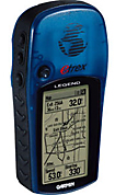
Garmin eTrex Legend
With the eTrex Legend, Garmin has loaded a full basemap of North and South America into one small unit. The Legend is also designed to provide precise GPS positioning using correction data obtained from the Wide Area Augmentation System (WAAS). This product will provide position accuracy to less than three meters when receiving WAAS corrections.
The Garmin eTrex Legend HCx is a WAAS-capable GPS receiver that is lightweight, compact and waterproof. You can add maps by inserting preprogrammed Micro-SD cards into the card slot which is located in the waterproof battery compartment. The cards contain MapSource data for your land/sea, street/terrain travels and can provide turn-by-turn directions. The Legend HCx has a color display and USB port for transfering data to your computer.
All of the information you need to operate the eTrex Legend can be found on five main pages (or display screens). You can press and release the Page button to cycle through the Satellite Page, Map Page, Navigation Page, Trip Computer, and Main Menu Page.
The Satellite Page shows satellite signal strength, displays when the unit is able to navigate, and tells the location by latitude/longitude. There is a Skyview graphic that shows the relative position of each satellite as if you were looking up at the sky. This display has each satellite's assigned number labeled. Also shown here are bars indicating signal strength for each satellite. The strength of the signal is represented by the height of the bar.
The Map Page displays your present position and direction of movement using a triangular Position Icon that is centered on the map. As you travel the map display leaves a trail (track log) of your movements. The map also displays geographic details such as major rivers, lakes, highways, and towns. A higher level of detail can be obtained by downloading maps from a CD ROM mapping program. The map scale can be changed from 20 feet to 500 miles.
The Navigation Page provides active guidance with a rotating compass ring that shows your course over ground (track) while youre moving and a bearing pointer to indicate the current direction to your destination (bearing) relative to the course over ground. The Status Window at the top of the page shows you the name of your destination, the distance, and the time to go. Two data fields are provided, and can be programmed to display a variety of navigation data. The bent (bearing) pointer arrow alerts you to the upcoming turn while you are navigating a route. When you get within 15 seconds ETA of the current point, the pointer bends to indicate the direction of the turn to the next point while still showing the direction to the current point.
The Trip Computer Page displays up to eight different types of navigation data and are user programmable. Each data field is selectable and can contain one of many data information options. By selecting the information options that you prefer and arranging them in a desired order on the page, you can customize the Trip Computer Page to meet your navigation needs.
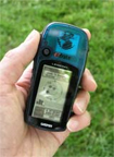
Garmin eTrex Legend GPS receiver trip page The Main Menu provides access to additional eTrex Legend feature pages. From the Main Menu Page you can mark and create new waypoints; find map items such as cities, interstate exits, addresses, points of interest, etc.; create routes; save tracks; setup system operating features; or access and use unit accessories.
The Garmin eTrex Legend is an entry level mapping receiver. A good choice for the outdoor enthusiast, the Legend can accommodate products like MapSource USA TOPO for backcountry maps and MetroGuide to show points of interest on the road. One of the most striking attributes of the Legend is its comfortable and efficient design. While it rests easily in the palm of either hand, it's most suited for the left hand, where its handy click-stick can be manipulated with the thumb. The click-stick works like the pencil-eraser nubbin on laptop PCs and is handy for moving through screen icons and menus.
For those interested in checking out their foot pace and distance traveled, it's a handy GPS to have in hand and a great value for your money.
|
|
|
 |
|
|
|
|
|
|