|
|
 |
Knowledge Is Key
For Intelligent Decisions
Satellite Logic is a leading,
authoritative source of information in
the Satellite Industry. Located in the
heart of the Silicon Valley, Satellite
Logic provides one of the most
valuable and comprehensive
knowledge bases on the Satellite
market! This is a primary Worldwide
information center which enables our
clients to analyze, evaluate, inquire
and select their best tailored
solutions. Our company sets the
industry standards for targeted
buying leads, reflecting a dramatic
advance over traditional marketing
solutions.
|
|
|
 |
 |
|
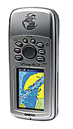
Garmin GPS 76 HandHeld
Part of the mariner-friendly 76-series handheld navigators, the GPS 76 is WAAS-enabled for accuracy to within 3 meters and features a large, crisp display and easy-to-use buttons.
As a device that can be used both on land and water, don't worry about losing this GPS device in the drink. The GPS 76 floats in water, and it's IPX7 waterproof to withstand the accidental dunk or splash in the lake. Whether on water or land, the GPS 76 can save up to 500 of your favorite places in memory and create a straight-line route to your destination.
The GPS 76 is preloaded with worldwide cities as well as marine navigation aids, including lights, buoys, sound signals and day beacons. If you're into boating, hunting or fishing, you can use the 76's built-in celestial data, which includes tide information, sunrise/sunset times and a hunting and fishing calendar.
Unit dimensions, WxHxD: 2.7" x 6.2" x 1.2" (6.9 x 15.7 x 3.0 cm)
Display size, WxH: 1.6" x 2.2" (4.1 x 5.6 cm)
Display resolution, WxH: 180 x 240 pixels
Display type: 4 level gray LCD
Weight: 7.7 oz (218 g) with batteries
Battery: 2 AA batteries (not included)
Battery life: 16 hours
Waterproof: yes (IPX7)
Floats: yes
High-sensitivity receiver: no
Interface: serial
RoHS version available: yes
Maps & Memory:
Basemap: no
Preloaded maps: no
Ability to add maps: accepts points of interest data
Built-in memory: no
Accepts data cards: no
Waypoints/favorites/locations: 500
Routes: 50
Track log: 2,048 points, 10 saved tracks
Features:
Automatic routing (turn by turn routing on roads): no
Electronic compass: no
Touchscreen: no
Barometric altimeter: no
Geocaching-friendly: no
Outdoor GPS games: no
Hunt/fish calendar: yes
Sun and moon information: yes
Tide tables: yes
Area calculation: yes
Custom POIs (ability to add additional points of interest): no
Unit-to-unit transfer (shares data wirelessly with similar units): no
Picture viewer: no
|
|
|
 |
|
|
|
|
|
|