|
|
 |
Knowledge Is Key
For Intelligent Decisions
Satellite Logic is a leading,
authoritative source of information in
the Satellite Industry. Located in the
heart of the Silicon Valley, Satellite
Logic provides one of the most
valuable and comprehensive
knowledge bases on the Satellite
market! This is a primary Worldwide
information center which enables our
clients to analyze, evaluate, inquire
and select their best tailored
solutions. Our company sets the
industry standards for targeted
buying leads, reflecting a dramatic
advance over traditional marketing
solutions.
|
|
|
 |
 |
|
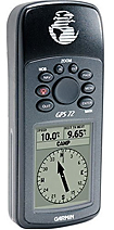
Garmin GPS 72 HandHeld
The main differences between the 72 and 76 models are that on 76 it tadds a connector for an external antenna, it has more pixels in the display (slightly sharper), and the model 76 package comes bundled with a PC Data cable. Both units offer the same performance, are the same physical size, have the same amount of memory, have the same display size, same type of antenna, offer tide prediction, and are water-resistant (submersible).
Although the display on the model 76 is a bit sharper than the display on the model 72, the 72 is cheaper. They both have a user manual. The GPS is easy to learn and easy to use.
he GPS 72 is a low-cost solution for land or marine navigation designed to provide precise GPS positioning using correction data obtained from the Wide Area Augmentation System (WAAS). The GPS 72 can provide position accuracy to less than three meters when receiving WAAS corrections. This rugged, waterproof, unsinkable GPS receiver offers a large, 4-level grayscale screen. It's designed as the next generation in basic, entry-level Garmin GPS.
This affordable land or marine navigation system replaces the best-selling Garmin® GPS 12 model. The newly updated version provides precise global positioning data obtained from the Wide Area Augmentation System (WAAS) while accessing 12 satellites to track your location. Completely waterproof and unsinkable, this GPS system calculates pinpoint accuracy on a backlit display for both day and night usage. Built-in celestial calendar makes this system useful to the hunter/fisher in identifying peak seasons.
Features:
# Requires 4 AA batteries (not included)
# Backlit display and keyboard
# 1 MB internal memory
# Water-resistant for up to 1 meter for 30 minutes
# 500 user waypoints with name and graphic symbol
# Position formats include Lat/Lon, UTM, Loran TDs, Maidenhead, MGRS, and user grid
# 50 reversible routes plus TracBack® modes
# Includes automatic track log that allow you to retrace path in both directions
# Built-in celestial tables for fishing and hunting, plus sun and moon calculations
# Automatic alarms for anchor drag, arrival, off-course, proximity waypoint, and clock
# Avg. Run Time: 16 hours
# Acquisition Time: 15-45 seconds; AutoLocate®, 5 minutes
# Position Accuracy: 15, 95%
# Velocity Accuracy: 0.05 meter/sec, steady state
# Display: High-contrast FSTN, 4-level gray scale, 120 x 160 pixels
|
|
|
 |
|
|
|
|
|
|