|
|
 |
Knowledge Is Key
For Intelligent Decisions
Satellite Logic is a leading,
authoritative source of information in
the Satellite Industry. Located in the
heart of the Silicon Valley, Satellite
Logic provides one of the most
valuable and comprehensive
knowledge bases on the Satellite
market! This is a primary Worldwide
information center which enables our
clients to analyze, evaluate, inquire
and select their best tailored
solutions. Our company sets the
industry standards for targeted
buying leads, reflecting a dramatic
advance over traditional marketing
solutions.
|
|
|
 |
 |
|
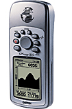
Garmin GPSMAP 76
The Garmin GPSMAP 76 and 76S are mariner-friendly handheld GPS designed for the serious outdoor enthusiast. There aren't many differences between them - we'll focus on that latter on. The Garmin devices come with a base map but have been designed to work with a number of additional downloadable maps.
Main features:
Waypoints/icons: 500 with name and graphic symbol, 10 nearest (automatic), 10 proximity
Routes: 50 reversible routes with up to 125 points each, plus MOB and TracBack® modes
Tracks: Automatic track log; 10 saved tracks let you retrace your path in both directions
Trip computer: Current speed, average speed, resettable max. speed, trip timer and trip distance
Alarms: Anchor drag, approach and arrival, off-course, proximity waypoint, shallow water and deep water
Tables: Built-in celestial tables for best times to fish and hunt, sun and moon rise, set and location
Map datums: More than 100 plus user datum
Position format: Lat/Lon, UTM/UPS, Maidenhead, MGRS, Loran TDs and other grids, including user grid
The Garmin GPSMAP76S receiver fits quite nicely into the palm of your hand. It is controlled by a small 4 way rocker pad surrounded by eight function buttons. The unit is reportedly completely waterproof and will even float if dropped overboard from a boat. One nice feature is that the base of the receiver is rubberised so will stay pretty much where you place it and will not slip out of your hand easily.
The display is a four shade FSTN screen with backlight. It has a high resolution screen of 180 by 240 pixels. On the back of the receiver there is the quarter turn battery locking mechanism hiding the two AA sized batteries. It is possible to use rechargeable cells, but you must bear in mind that they supply 2.4 volts as opposed to 3 volts. Also on the back located behind a rubber gasket is the Garmin proprietary interface connector. It is this connector that allows the Garmin to be interfaced to either a PC or more importantly your PDA.
Well the first thing to do is to get a satellite fix and the Garmin receiver had managed to perform a factory fix in a very short time. Partly due to the superb Quad Helix antenna that the GPSMap76S has. Holding a fix is just as important as getting the first fix, and here the Garmin excelles.
WAAS stands for Wide Area Augmentation System. It's a system of satellites and ground stations that provide GPS signal corrections, giving you even better position accuracy, sometimes up to five times better. A WAAS-capable receiver can give you a position accuracy of better than three meters, 95 percent of the time, and you don't have to purchase additional receiving equipment or pay service fees to utilize WAAS.
The Garmin's WAAS is good, but it does not come configured as standard. You need to go into the Setup Menu and enable WAAS. How can you tell if you are getting WAAS fixes? First of all on the sky page you will see differential fix messages and in the satellite strength bars a 'D' will appear indicating that the satellite is being used in the WAAS fix.
Configuring the GPSMap76S to use the interface as NMEA will allow you to output the data to a Pocket PC, or PC and use any NMEA compliant GPS application on these devices to use the GPS data feed from the Garmin handheld. The baud rate is automatically set to 4800 and cannot be changed but this really isn't a limitation as most GPS Receivers that work in NMEA mode default to 4800 or prefer to work at 4800 baud.
The Garmin has sets of displays named pages. These are the Satellite Page, the Map Page, the Compass page, the Highway page, the Route page.
The satellite page provides basic information about the satellite positions and strengths. It also shows details such as your position in selected co-ordinates, speed, height and accuracy. The map page shows the available map data, superimposed with you route, waypoints, tracks etc. You can either have a full screen map or you can show some information at the top of the screen. By default the fields are your speed, and the distance to the next waypoint on your route.
By pressing the menu button you can set up the fields displayed on the screen, and other options for the map display. In general this applies to all pages. Pressing the menu button displays context sensitive options for the page as shown on the right. Pressing the menu button again will display the main setup menu.
The GPSMap76S comes built-in with an Electronic Compass. The compass is best used for navigation when a straight line course cannot be followed. The compass page has several user selectable fields. There are two options on the GPSMap76S that the compass page can use. Firstly it can navigate using the electronic compass, or it can navigate using the GPS Receiver. When travelling at 10mph or less for more than 90 seconds, the GPSMap76S is programmed out of the factory to use the Electronic Compass. When travelling over 10mph the GPSMap76S will switch back to using the GPS Receiver for navigation. These settings can be changed if you want. When you are travelling directly toward the waypoint, the pointer will line up with the vertical line in the compass ring.
The GPSMap76S has a built-in Electronic Barometer. With a proper barometer you should not see this increase or decrease when moving up or down except for when the atmospheric pressure changes. This is where the Garmin GPSMap76S's Electronic Barometer comes in handy as it operates as you would expect an Electronic Barometer would operate. You will have to calibrate the GPS Receiver which can take up to an hour for the calibration of the barometer.
There are a few noticeable differences between the GPSMap76S and the GPSMap76, apart from the price which is one, check out the following feature differences.
* The first major difference between the GPSMap76 and GPSMap76S is the amount of memory available for loading MapSource maps into. The GPSMap76 currently only has 8mb RAM where the GPSMap76S has 24mb which allows for loading of larger map segments.
* The second major difference is that the GPSMap76S has a built-in Electronic compass which allows you to hold the GPS at any angle and still get a proper reading from it.
* The third major difference is that the GPSMap has a built-in barometric altimeter.
* The case colour on the GPSMap76S is a lot nicer in a more metallic look
* One of the downsides to the GPSMap76S is it only has around 10 hours battery runtime compared with the GPSMap76 which has a runtime of around 16 hours.
The GPSMap76S is a great handheld, it's waterproof has an electronic compass and barometer, and is probably one of the better Garmin handheld's for hiking, mountaineering and fell walking.
|
|
|
 |
|
|
|
|
|
|