|
|
 |
Knowledge Is Key
For Intelligent Decisions
Satellite Logic is a leading,
authoritative source of information in
the Satellite Industry. Located in the
heart of the Silicon Valley, Satellite
Logic provides one of the most
valuable and comprehensive
knowledge bases on the Satellite
market! This is a primary Worldwide
information center which enables our
clients to analyze, evaluate, inquire
and select their best tailored
solutions. Our company sets the
industry standards for targeted
buying leads, reflecting a dramatic
advance over traditional marketing
solutions.
|
|
|
 |
 |
|
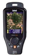
Bushnell ONIX 350
Bushnell's Onix 350 Handheld GPS Navigation System is the world's first handheld GPS to combine navigational aids and georeferenced satellite photography on a single screen. The Onix 350 allows users to download maps and images to their unit, which then instantly calibrates the images to GPS satellites for navigation use. Housed in a rugged, rubber armor, the Onix 350's extra-large 3.5'' color LCD screen offers a clear view of your surroundings. Runs 32 hours on rechargeable lithium-ion battery (included).
Whereas all other dedicated GPS units rely on vector based graphics to display maps, trails and waypoints, the ONIX350 possesses the ability to rasterize a georeferenced satellite or aerial image on its large, vivid 3.5" screen. This results in a "real life" view of the area being navigated and is able to be layered over a vector-based map; switchable from one view to another with a push of a button. The ability to reference a true image of a route and its associated visual landmarks greatly simplifies and enhances navigation by GPS. Furthermore, the ONIX350 is bestowed with a range of features that allow users to use its advanced functionalities in demanding conditions.
Bushnell Onix 350 GPS Digital Navigation System 363500 allows you to navigate and plan your adventures using actual satellite images and aerial photography. Download an image to your GPS unit and it's instantly calibrated (georeferenced) to the satellites for navigation. Now, the landmarks around you are pictured in your palm. The Onix 350 CR GPS Nav System by Bushnell consists of a screen-layering feature that creates the most user-friendly interface on the market. This Bushnell GPS, like its Onix 400 and Onix 200CR siblings, provides exclusive features such as SafeTrack battery-conservation mode, HOT button operation, WAAS-enabled 20 channel SiRF GPS receiver and a fully colored LCD, to name a few. With storage support of over 150 satellite photo and topography map downloads (did we mention the screen layering capabilities), the Bushnell Onix 350CR GPS Digital Navi System 36-3500 grants you the power to fully utilize an incredibly advanced handheld GPS that's also simple to use.
Features:
Built-in basemap of U.S. and Canada
Specific displays for water navigation
3.5" color LCD screen
Displays satellite photography downloads
Solunar Edge Technology for advanced fish finding and animal activity prediction
Exclusive screen layering
Waterproof (IPX7 rated)
SafeTrack battery conservation mode
SiRF® Star III 20-channel GPS receiver
Self calibrating 3-axis digital compass
Barometric pressure sensor with elevation profiles
Weather forecaster with current temperature
Rugged rubber armor
Built-in 512 MB MicroSD card
|
|
|
 |
|
|
|
|
|
|