|
|
 |
Knowledge Is Key
For Intelligent Decisions
Satellite Logic is a leading,
authoritative source of information in
the Satellite Industry. Located in the
heart of the Silicon Valley, Satellite
Logic provides one of the most
valuable and comprehensive
knowledge bases on the Satellite
market! This is a primary Worldwide
information center which enables our
clients to analyze, evaluate, inquire
and select their best tailored
solutions. Our company sets the
industry standards for targeted
buying leads, reflecting a dramatic
advance over traditional marketing
solutions.
|
|
|
 |
 |
|
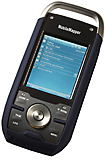
Magellan Professional MobileMapper 6
The new MobileMapper 6 Office tool can be used to differentially post-process raw GPS data collected with the Magellan Mobile Mapping software. Through post-processing, the positions of every GIS feature you collect in the field can be improved to 1-2 meters accuracy.
Thanks to BLADE Magellan unique processing algorithm, post-processing raw data with MobileMapper 6 Office is extremely efficient and straightforward. Through an Internet connection, MobileMapper 6 Office can automatically find and download the base data files that will match the collected raw data. MobileMapper 6 Office also allows project preparation, synchronization with Mobile Mapping software and the management of your GIS maps and data.
MobileMapper 6 provides a complete set of all necessary features required by a mapping device for anyone who needs productive data collection and efficient asset management in the field. Unlike consumer-grade units, the low-cost easy-to-use MobileMapper 6 offers full compatibility with popular GIS software to enable companies to select and use GIS software of choice. With MobileMapper 6, Magellan innovates and fills a market gap in GIS data collection between high-cost devices and consumer-grade products.
This SBAS enabled high-sensitivity GPS receiver continuously tracks up to 12 satellites to compute and update your position (2-5m accuracy) even in difficult conditions, such as under tree canopy and urban surroundings.
The MobileMapper 6 comes with Microsoft Windows Mobile 6, a color touch-screen and has Bluetooth for wireless connectivity. You can collect GIS/GPS points and maps via the GIS application of your choice, navigate, and communicate wirelessly.
Fits comfortably in one hand and weighs less than eight ounces (224g). MobileMapper 6 is made for intensive use and can be dropped in the dirt or into water again and again. It keeps working, and you wont lose any data.
With SD card storage, keep GIS raster maps, photos, videos, and any other data on hand and never worry about running out of memory in the field.
Embedded speaker and microphone make it easy to record audio files, for a rich archive of locations and projects. You can also take pictures using the integrated 2-megapixel digital camera, use Windows Office Mobile applications, all with a single device.
Software solutions:
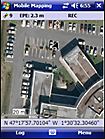
Mobile Mapping: Magellan software for professional and easy GIS data collection.
DigiTerra Explorer: Fast, effective and easy-to-use GIS software.
ESRI ArcPad (USA only): Mobile GIS and field mapping software for ArcGis users.
GPS Characteristics:
GPS chipset: SiRFstarIII
GPS accuracy (SBAS): 2-5 m
Channels: 12 (L1 code)
Antenna type: Patch
Supported protocols: NMEA and SiRF
Update rate: 1 Hz
|
|
|
 |
|
|
|
|
|
|