|
|
 |
Knowledge Is Key
For Intelligent Decisions
Satellite Logic is a leading,
authoritative source of information in
the Satellite Industry. Located in the
heart of the Silicon Valley, Satellite
Logic provides one of the most
valuable and comprehensive
knowledge bases on the Satellite
market! This is a primary Worldwide
information center which enables our
clients to analyze, evaluate, inquire
and select their best tailored
solutions. Our company sets the
industry standards for targeted
buying leads, reflecting a dramatic
advance over traditional marketing
solutions.
|
|
|
 |
 |
|
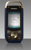
Magellan Professional MobileMapper CX
Magellan, a leader in GPS navigation and positioning, introduced the MobileMapper CX, a handheld GPS receiver for GIS users that offers Magellans exclusive Mobile Mapping application software, a phone-like keypad for convenient data entry, and outstanding communications. This sub-meter real-time receiver enables unprecedented productivity at a cost significantly lower than competitive receivers.
The MobileMapper CX comes standard with intuitive Mobile Mapping application software from Magellan that features all the functions GIS users need most. The software is elegant and simple, making proficient use quick and easy with minimum training. Key GIS data logging capabilities include GIS feature libraries for logging feature descriptions; support for logging point, line and area features; an offset function for logging hard to reach features; and more.
In addition, a nesting function lets customers log features without closing other features already being logged. For example, a utility worker could insert a telephone pole while mapping a road, without time-intensive screen opening and closing.
In addition to receiving Magellan Mobile Mapping software, MobileMapper CX customers can purchase the Magellan MobileMapper CX in any of three configurations:
1. With Magellans post-processing module;
2. MobileMapper CX as an open-platform standalone unit ready for use with any of a wide variety of custom and third-party software applications;
3. Bundled with ESRI ArcPad -- the best-selling GIS field software on the market.
Unlike any GIS data collector in its class, the familiar look and feel of a typical cell phone keypad interface permits one-handed operation of the MobileMapper CX that users find convenient. The ability MobileMapper CX delivers to users to immediately enter data and manipulate the device with speed and efficiency shortens the learning curve and makes field use easy.
Driven by the market trend toward and customer need for ubiquitous wireless and network connectivity, MobileMapper CX delivers Bluetooth and WiFi, so mobile users can access the Internet easily or communicate with remote systems and networks, such as a collected data exchange. This also allows customers to get DGPS corrections for enhanced accuracy. The WiFi works like a charm and it finds the network immediately. Just log on and you're browsing the web.
MobileMapper CX employs the latest Microsoft Win CE.NET 5.0 operating system to facilitate custom application software development by third-party software integrators. With the latest CE 5.0 software, you can be sure that all the latest third-party software packages will run on the MobileMapper CX.
The positive feedback received from the beta testers who have put MobileMapper CX to the test in real world conditions affirms the high quality of the CX. Magellan designs GIS solutions that bring real efficiency, powerful performance, and convenience to the field. MobileMapper CX is a great example of the rich features and aggressive price it brings to the market.
To further extend the value of MobileMapper CX for customers, an extended memory of up to 4 GB of SD storage permits large files, such as complex maps and GIS data bases, to be downloaded for field use and large amounts of field-collected data to be readily uploaded.
The MobileMapper CX retains the low-cost, high-accuracy (sub-meter in real time, sub- foot when post-processed) and rugged yet lightweight form factor that made its predecessor, the MobileMapper CE, the standard for performance and affordability in handheld GPS receivers for GIS.
|
|
|
 |
|
|
|
|
|
|