|
|
 |
Knowledge Is Key
For Intelligent Decisions
Satellite Logic is a leading,
authoritative source of information in
the Satellite Industry. Located in the
heart of the Silicon Valley, Satellite
Logic provides one of the most
valuable and comprehensive
knowledge bases on the Satellite
market! This is a primary Worldwide
information center which enables our
clients to analyze, evaluate, inquire
and select their best tailored
solutions. Our company sets the
industry standards for targeted
buying leads, reflecting a dramatic
advance over traditional marketing
solutions.
|
|
|
 |
 |
|
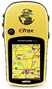
Garmin eTrex Venture Cx
The eTrex Venture Cx is the entry level mapping GPS from Garmin. The C means its a color screen, and the x means expandable memory, in this case through microSD cards. The next one up the totem pole is the Legend Cx, which includes a 32mb memory card.
The Garmin eTrex Venture CX, like its brother the Garmin eTrex Legend CX, makes for a durable, versatile recreational GPS unit that is likely to become indispensible. Unlike its brother however, the Garmin eTrex Venture CX lacks the bells and whistles, like microSD card and USB connection that make the former a bit more expensive. The Garmin eTrex Venture CX comes ready to use right out of the box, and comes preloaded with Americas Recreational Routing Basemap.
The Garmin eTrex Venture CX is set apart from other recreational GPS units by its impressively bright, full-color TFT display. Maps, atlases and other valuable information to be accessedeven at night.
Handheld GPS receivers are great companions for a wide range of outdoor activities, including exercise walking, day-hiking, backpacking, hunting, fishing, kayaking, birdwatching and more. A handheld GPS can tell you how far you've traveled and how fast, where you are, and if you have entered a pre-set route, where you are going and how to get there. Higher-end handhelds are loaded with features, and can be reliable travel guides under the most demanding outdoor conditions. That's the job of the new eTrex Legend HCx by Garmin.
For a handheld to be truly useful for outdoor navigation, it needs a moving-map display, and better yet, a bright, high-resolution, color display. This model meets those criteria with a sharp and clear 1.3-inch by 1.7-inch, 256-color, 176 by 220 pixel display. The display brightness is quickly adjustable to three levels, the brightest of which is easily visible in bright sunlight. You may move the directional cursor around the screen with a thumb-stick unique to Garmin handhelds.
The eTrex Legend HCx has an extensive list of features and functions. Topping the list is its ability to obtain GPS satellite signals even under heavy forest cover or while in steep terrain. The H in the models HCx designation indicates it comes with the latest-generation high-sensitivity receiver and chip. The eTrex Legend HCx is also WAAS enabled which means that it can use signals from the Wide Area Augmentation System where available (most of North America and North Americas coast), further increasing position accuracy to within three meters.
The eTrex has a thumb stick that can be used to pan the map or to scroll and highlight menu items. You navigate its functions via four pages, including the map page, compass page, altimeter page, and the main menu. The map is truly useful and informative, and if youve loaded a supplemental topographic map, provides a very detailed rendering of off-road terrain.
The compass screen presents a compass graphic and includes speed, distance estimated time of arrival stats. The altimeter page shows you the current elevation rate of ascent and descent, and the best feature, a profile of elevation change over time. The main menu page gives you access to all pages and control over all of the settings.
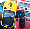
The eTrex Legend HCx comes with Garmin Mapsource software that manages map downloading and permits route and elevation profile plotting. Mapsource also stores uploaded routes. The eTrex connects to a personal computer via an included USB cable. The eTrex also has a slot (under the battery cover, away from dirt and water) for a microSD memory card. You may purchase microSD cards from Garmin that are preloaded with detailed topo, marine, and highway maps.
There are a couple of downsides: While very sturdy (its battery cover is made of rubber-armored cast metal, for example) the eTrex is a bit heavy, at 5.5 ounces including two AA batteries, for load-weight-conscious backpackers or mountain bikers. Also, to make the unit truly useful in the outdoors, you will need to purchase a supplemental regional topo map set on microSD card from Garmin for $86. To be fair, other handhelds require supplemental map purchases as well, but factor in the added expense.
Key features of the eTrex Venture Cx:
* Display: 1.3"W x 1.7"H, 256-color, high resolution, transflective TFT
* Weight: 5.6 ounces with batteries (not included)
* Battery Life: Up to 32 hours with typical use using two AA alkaline batteries
* Auto-route basemap: General map data including highways, major roads rivers, lakes and borders. Provides turn-by-turn directions with optional preprogrammed City Navigator cards
* microSD card slot: Allows for storage of most MapSource products including BlueChart, City Navigator, U.S. TOPO 24K, U.S. TOPO and Recreational Lakes with Fishing Hot Spots
* Waterproof: IEC 60529 IPX7 standards submersible in one meter of water for up to 30 minutes
* Waypoints/Routes/Tracks: 500 user waypoints with name and graphic symbol; 20 reversible routes, 50 points per route. 10,000 point automatic track log; 20 saved tracks (500 points each) let you retrace your path in both directions
Summing up, the eTrex Legend HCx is an excellent handheld for avid day-hikers, backpackers, kayakers (the eTrex is rated as waterproof and did not leak in my immersion test), hunters and fishermen. In fact anyone spending a lot of time navigating outdoors who needs a very rugged handheld with a good, color, moving-map display and the ability to add detailed topo maps.
Pack more detail into your adventure with the eTrex Venture Cx. You won't miss a thing when you'll take this lightweight, easy-to-use handheld out hiking, biking, camping, fishing or geocaching. Highly recommended!
|
|
|
 |
|
|
|
|
|
|