|
|
 |
Knowledge Is Key
For Intelligent Decisions
Satellite Logic is a leading,
authoritative source of information in
the Satellite Industry. Located in the
heart of the Silicon Valley, Satellite
Logic provides one of the most
valuable and comprehensive
knowledge bases on the Satellite
market! This is a primary Worldwide
information center which enables our
clients to analyze, evaluate, inquire
and select their best tailored
solutions. Our company sets the
industry standards for targeted
buying leads, reflecting a dramatic
advance over traditional marketing
solutions.
|
|
|
 |
 |
|
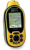
DeLorme Earthmate PN-20
If you are the outdoors type and like outdoors challenges, the DeLorme Earthmate PN-20 is for you! This is definitely an outstanding handheld GPS receiver, a very robust and useful resource for those who work or play outdoors.
The Earthmate PN-20 features a sharp and bright color mapping display, sturdy construction, quick signal acquisition, and a logical and easy-to-use button layout.
Why is the Earthmate PN-20 above the others and what sets it apart? First, is its ability to accept downloads of satellite and aerial imagery, and to show and pan these images as one of the map layer display options. Secondly, its tight integration with DeLorme's Topo USA software for the personal computer and DeLorme's extensive downloadable map selection extend its usefulness and help you plan and analyze trips in detail, and from multiple perspectives. Third, DeLorme's bundling options, which include additional maps, separate chargers, a rechargeable lithium battery pack, and other travel goodies at a lower cost than separate purchases.
The PN-20 is so integrated with its included personal computer software and DeLorme online, that it is really part of a system. That's why DeLorme has decided to sell the PN-20 receiver as part of one of three bundles.
The lowest price bundle is called the Earthmate GPS PN-20 with Topo USA 7.0 National.
This bundle includes:
* The Earthmate GPS PN-20 handheld GPS receiver.
* DeLorme Topo USA software with full U.S. topographic and street-level detail.
* Pre-loaded worldwide highway and major road base map.
* Certificate for $100 worth of data downloads.
* USB interface cable.
* Neck lanyard.
* Two AA batteries.
* Comprehensive user's manual with usage scenario tips.
The second - the Earthmate GPS PN-20 with Topo USA 7.0 National & Power Travel Kit bundle includes all of the above plus a travel power kit recharger and rechargeable Lithium-Ion battery.
The third - the Earthmate GPS PN-20 Deluxe bundle which includes all of the above plus a 1GB SD Card and reader.
The PN-20 has a long and impressive list of functions. Highlights of the unit include a color moving map display; high-sensitivity receiver (picks up GPS satellite signals in heavy forest cover or steep terrain); a slot (under the sealed battery case and away from water and dirt) for a removable SD Card for quick transfer of large amounts of data, and a rubberized, heavy-duty waterproof case.
The PN-20's display sets are organized by "pages" that can be changed by pressing the "page" button. These include a satellite page to view satellite reception status; the map page with plenty of options; a compass page that shows the simulated compass; trip info; "find" waypoints, address, etc.; waypoints; routing; tracks; sun/moon; hunt/fish, and setup.
In general the page control button and feature accessibility are logical and well organized. Like any advanced handheld GPS with many features, the PN-20 requires that you spend time reading the manual and exploring how the buttons control the pages and options.
DeLorme made its name in maps, and as you would expect, the included and optional maps, control of maps with the included Topo USA software, and import and export of maps are well done. The PN-20 can also display satellite and aerial images as a map display "layer" and these are available online as well.
The PN-20 comes pre-loaded with a simple basemap set that is of limited use. However, after you have installed Topo USA on your computer and made the connection with your PN-20, you may select from enhanced topographic and street maps for the entire USA from the included Topo USA 7.0 DVD. You also receive with any PN-20 bundle a certificate number that entitles you to $100 worth of data downloads including: USGS 1:24,000 quad maps; NOAA nautical charts; High-resolution color aerial imagery - U.S. States; High-resolution color aerial imagery - Select U.S. Cities; Black-and-white aerial imagery, and 10-meter color satellite imagery.
Once you have selected the maps you would like to download to the PN-20, you may transfer them by included USB cable or (more quickly) by SD card.
The Topo USA software is more than a map database. It is the most full-featured and sophisticated map management program on the market for consumers. If you are a map enthusiast, or a serious outdoorsperson or geocacher, you will find plenty of functions to help you plan routes and precisely select and manage the maps you'll need.
Out in the field, the PN-20's bright color display is easily viewable in full daylight. When pre-loaded with detailed maps and aerial or satellite imagery, it provides an excellent overview of the terrain and what you will encounter as you travel. Its button setup, map pan and zoom features and display page choices become intuitive with some practice. Its sturdy, waterproof, rubberized case holds up well to hard outdoor use.
Overall, the PN-20 is a fine choice for the serious outdoorsperson, and its complementary software and map base will please map enthusiasts, people who want to create and share detailed routes, and professionals who need extensive maps and map features.
|
|
|
 |
|
|
|
|
|
|