|
|
 |
Knowledge Is Key
For Intelligent Decisions
Satellite Logic is a leading,
authoritative source of information in
the Satellite Industry. Located in the
heart of the Silicon Valley, Satellite
Logic provides one of the most
valuable and comprehensive
knowledge bases on the Satellite
market! This is a primary Worldwide
information center which enables our
clients to analyze, evaluate, inquire
and select their best tailored
solutions. Our company sets the
industry standards for targeted
buying leads, reflecting a dramatic
advance over traditional marketing
solutions.
|
|
|
 |
 |
|
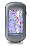
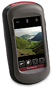
Garmin Oregon 400i
Oregon 400i puts freshwater fun at your fingertips. This next-generation handheld features a rugged touchscreen along with preloaded U.S. Inland lakes Vision, a high-sensitivity receiver, barometric altimeter, electronic compass, microSD card slot, picture viewer and more. Even exchange tracks, waypoints, routes and geocaches wirelessly between similar units.
Oregon 400i leads the way with a tough, 3-inch diagonal, sunlight-readable, color, touchscreen display. Its easy-to-use interface means youll spend more time enjoying the outdoors and less time searching for information. Both durable and waterproof, Oregon 400i is built to withstand the elements. Bumps, dust, dirt, humidity and water are no match for this rugged navigator.
Oregon 400i comes with built-in U.S. Inland lakes Vision mapping and a worldwide basemap with satellite imagery perfect for all your outdoor pursuits. Map detail includes shoreline details, depth contours, boat ramps and mile markers for thousands of lakes in the continental U.S. See list of lakes covered by region: North Central, Northeast, South Central, Southeast, West.
With Oregon 400i you can share your waypoints, tracks, routes and geocaches wirelessly with other Oregon and Colorado users. Now you can send your favorite hike to your buddy to enjoy or the location of a cache to find. Sharing data is easy. Just select send to transfer your information to other Oregon or Colorado units.
Oregon 400i supports Geocaching.com GPX files for downloading geocaches and details straight to your unit. No more manually entering coordinates and paper print outs! Simply upload the GPX file to your unit and start hunting for caches. Oregon supports Wherigo, the newest GPS-based activity from Groundspeak, the people who made geocaching a worldwide phenomenon. Show off photos of your excursions with Oregons picture viewer. Slim and lightweight, Oregon is the perfect companion for all your outdoor pursuits.
With its high-sensitivity, WAAS-enabled GPS receiver and HotFix satellite prediction, Oregon 400i locates your position quickly and precisely and maintains its GPS location even in heavy cover and deep canyons. The advantage is clear whether youre in deep woods or just near tall buildings and trees, you can count on Oregon to help you find your way when you need it the most.
Easy to learn and simple to use, the waterproof Garmin Oregon 400i features a high-sensitivity GPS receiver and preloaded U.S. inland lake and navigable river maps that provide boaters and anglers with shoreline details, depth contours, boat ramps and mile markers for thousand of lakes. The chart detail includes shoreline, depth contours, navaids and port plans. It also offers a high-resolution, color 3-inch touchscreen that reacts as you tap or drag through menus and options. With its high-sensitivity, WAAS-enabled GPS receiver and HotFix satellite prediction, Oregon 400i locates your position quickly and precisely and maintains its GPS location even in heavy cover and deep canyons. It's also equipped with a barometric altimeter and electronic compass, and it's compatible with Garmin's heart-rate monitors and speed/cadence sensors.
The Oregon 400i lets you customize five profiles--automotive, marine, recreation, fitness or geocaching--making the most beneficial features for each activity the easiest to access through quick shortcuts. The tough, 3-inch color touchscreen display is easy to read even in direct sunlight, and the Oregon's easy-to-use interface means you'll spend more time enjoying the outdoors and less time searching for information.
It also plays well with others, allowing for wireless exchange of tracks, waypoints and geocaches between other Oregon units and Garmin Colorado models.
Oregon 400i has a built-in electronic compass that provides bearing information even while you're standing still, and its barometric altimeter tracks changes in pressure to pinpoint your precise altitude. You can even use the altimeter to plot barometric pressure over time, which can help you keep an eye on changing weather conditions.
Garmin's HotFix capability automatically calculates and stores satellite locations, greatly reducing satellite acquisition time so that you can turn the unit on and get going. Geocaching is even easier with the Oregon, which quickly downloads online information for every cache, such as location, terrain, difficulty, hints and description, so that you don't have to tote printouts with you.
|
|
|
 |
|
|
|
|
|
|