|
|
 |
Knowledge Is Key
For Intelligent Decisions
Satellite Logic is a leading,
authoritative source of information in
the Satellite Industry. Located in the
heart of the Silicon Valley, Satellite
Logic provides one of the most
valuable and comprehensive
knowledge bases on the Satellite
market! This is a primary Worldwide
information center which enables our
clients to analyze, evaluate, inquire
and select their best tailored
solutions. Our company sets the
industry standards for targeted
buying leads, reflecting a dramatic
advance over traditional marketing
solutions.
|
|
|
 |
 |
|
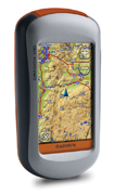
Garmin Oregon 300
The Garmin Oregon 300 is Garmin's latest hand-held navigation unit and is aimed at both basic and advanced navigation use. The combination of a new touch screen interface and, from early November, the ability to load OS mapping should extend its versatility even further and make it far more user-friendly than most previous GPS units.
The Oregon 300 sits in the middle of Garmins new range of rugged, touch screen-enabled handheld GPS devices. It offers more features over the entry level 200 unit, including more memory and a built in compass and altimeter. It comes with a preinstalled wordwide basemap, and you can install additional detailed maps separately, while the high-end 400 model comes with European topo maps.
The Oregon is compact and chunky in design, and ruggedised to protect it from the elements during everyday use. The exterior is clean, with just a single button to turn the device on and off, and a mini USB port well protected beneath a watertight plastic cover. There is a micro SD card slot located underneath the battery. Its not the most accessible, but is unlikely that you will be changing cards regularly anyway. The Oregon sits very nicely in the hand, aided by a slight rubberised coating to give added grip.
The new Oregon adds some interesting new features to the stuff you'd expect from any top-end GPS unit. A micro-SD Card slot means that you can upload mapping - more of which in a second - and also means massive storage for saving waypoints and routes.
The really interesting bit is that from early November, you'll be able to upload OS mapping to the Oregon allowing you to see your exact position on a proper OS map on the screen in front of you. Because the unit uses vector base mapping under the rasterised OS map, it can also plan routes ahead for you, remember where you've been and use a database of information to, say, tell you where the nearest cafe is and take you there turn by turn.
A new HotFix feature automatically calculates and stores crucial satellite information and speeds up position finding without waiting for data collection from satellites.
The device is something of a jack of all trades system, with pre-installed application for a wide variety of functions, ranging from leisure pursuits such as geocaching and fishing to fitness training and hiking. The software uses a profiles system to help you access the applications you need: switch to the geocaching profile and all the associated geocaching tools are moved to the first menu screen and within easy reach. There are five such profiles and you can create more if you need them.
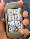
Ease of use like this is a key feature of the Oregon. With no external buttons all controls take place through the touch screen, so an effective interface is essential. It might be a cliché to describe the Oregon as the iPhone of GPS devices, but it is a fair comparison. The interface is so clear and so intuitive (and the screen responsive) that the device is immediately useable by even those who have never used one before. Just about all of the main functions of every application can be accessed with no more than two or three screen taps, and it is impossible to get lost within a program since the main menu is never more than a couple of taps away.
This simplicity in the software makes the device an absolute joy to use, but never comes at the expense of functionality. There are even a few added extras such as a picture viewer, the ability to share tracks and waypoints wirelessly with other Garmin users and, with the right maps installed, support for on-road navigation.
However it is not all perfect as the Oregon comes with a couple of minor caveats and one more serious concern. The least of the caveats is the electronic compass, which has to be held level in order for it to work and so is not quite as easy to use as it might be. More importantly the GPS receiver is not as sensitive as we have seen elsewhere, losing its signal fairly under dense cover. It regains it again very rapidly so is not a major issue, but is certainly something worth considering.
The 300 is a truly impressive piece of kit. The software is intelligently designed and fun to use and the unit has bags of functionality for a wide range of users and uses.
|
|
|
 |
|
|
|
|
|
|