|
|
 |
Knowledge Is Key
For Intelligent Decisions
Satellite Logic is a leading,
authoritative source of information in
the Satellite Industry. Located in the
heart of the Silicon Valley, Satellite
Logic provides one of the most
valuable and comprehensive
knowledge bases on the Satellite
market! This is a primary Worldwide
information center which enables our
clients to analyze, evaluate, inquire
and select their best tailored
solutions. Our company sets the
industry standards for targeted
buying leads, reflecting a dramatic
advance over traditional marketing
solutions.
|
|
|
 |
 |
|
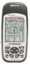
Lowrance iFinder Expedition C
Lowrance iFinder Expedition C was designed specifically for hiking and outdoors activities. The casing is shiny plastic, 30mm at its thickest point, 142mm tall and 64mm wide. The screen is a large 2.8in with loads of space around the screen. The iFinder is light and tough, waterproof to a metre's depth (the IPX7 standard). There's a thick rubber strip wrapped around the edges of the iFinder, which makes gripping it with gloves easy, and gives it a modicum of protection in the event of a drop.
The Expedition c is powered by a pair of AA batteries, which will last for up to 14 hours of continuous operation. As devices such as these are often used in locations far away from civilisation, it means you can keep it running wherever you find yourself. After all, AA batteries are easier to lay your hands on than a compatible power point. Sailors will be pleased to find that the Expedition c also comes with a 12V car adapter.
Ease of use is excellent. Each of the buttons of the front is clearly labelled and the menus are easy to understand. There may be a bit of a learning curve if you haven't used a hiking GPS before, but you'll get it pretty fast.
Holding the Pages button down while in sleep mode temporarily activates the compass mode - useful if you're trying to eke some more battery life out of the iFinder; while pressing Exit four times in a row launches a speedo mode. The map screen can be tweaked to your heart's content, with all sorts of overlays and information available, from a transparent compass dial to latitude and longitude grid lines, altitude, odometer information and more.
Features are right up there with the best recreational GPS devices too. Not only does the device boast GPS, but also a barometric altimeter - which can be used to track your altitude or plot atmospheric pressure history (and even predict the weather) - a digital compass, and extra mapping can be added to the device via MMC/SD card. A quick hunt online revealed most of the products available for the iFinder appear to be US focused, with no topographic maps available for Europe or the UK, which is disappointing. Marine maps are available for west and northern Europe, however.
But one of the device's most interesting features is that it's EGNOS (European Geostationary Overlay Service) ready. This is a system, put in place in recent years - and still in its experimental stages - aimed at improving the accuracy of GPS. Originally intended to assist pilots and aircraft, the system can be used by anyone with a compatible device, and despite the system not being completely finished, during tests in open countryside the iFinder picket up an EGNOS signal - indicated by an asterisk on the bars of the GPS status screen.
It's difficult to know how much this affected performance and accuracy, but one thing is clear - the Expedition c is incredibly accurate and responsive - one of the most accurate hiking GPS you'll find. Tracks are plotted very finely and on a quick walk you will be able to see precisely where you stopped and crossed a road.
GPS performance is exceptional too, with the Expedition c picking up a full lock in ideal conditions in under 30 seconds. Impressively, it maintains a solid position under light and heavy tree cover, and more importantly with the device warmed up, the iFinder is able to pick up a satellite lock almost instantly on the rare occasion that it lost signal.
Bottom line, the iFinder Expedition c, despite its size and a bit looks, is a highly impressive hiking GPS. It doesn't have the fancy mapping bells and whistles of Garmin's devices, but its performance is excellent and that's what you need when you're out on the trail.
|
|
|
 |
|
|
|
|
|
|