|
|
 |
Knowledge Is Key
For Intelligent Decisions
Satellite Logic is a leading,
authoritative source of information in
the Satellite Industry. Located in the
heart of the Silicon Valley, Satellite
Logic provides one of the most
valuable and comprehensive
knowledge bases on the Satellite
market! This is a primary Worldwide
information center which enables our
clients to analyze, evaluate, inquire
and select their best tailored
solutions. Our company sets the
industry standards for targeted
buying leads, reflecting a dramatic
advance over traditional marketing
solutions.
|
|
|
 |
 |
|
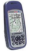
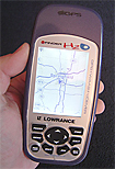
Lowrance iFinder H2O
Designed for anglers, boaters, and outdoors enthusiasts, the Lowrance iFINDER H2O is a totally waterproof handheld is rugged enough to handle any harsh environment. The Lowrance iFINDER H2O comes with sporty styling and a sure-grip rubber welt seal, along with dual processors and a high-res screen!
Lowrance iFINDER H2O Display
* 240V x 180H pixel resolution
* 3'' (7.6 cm) diagonal display size
* High contrast Film SuperTwist
* White LED backlit screen
* 16-level grayscale
* Excellent direct sunlight and low-light/night viewing
Lowrance iFINDER H2O Specs
* Weighs 8.7oz/247g with 2 AA batteries loaded (batteries not included)
* 5.6 x 2.5 x 1.2 inches / 14.2 x 6.5 x 3 cm pocket-sized
Lowrance iFINDER H2O GPS/Mapping
* Precision 12-parallel channel GPS+WAAS receiver
* Antenna port for connecting optional external GPS+WAAS antenna
* Dual processors for higher speed screen updates and scrolling
* Dual Easy/Advanced operation modes
* Built-in, detailed Lowrance background map featuring interstate exit services
* One MMC/SD digital media memory card slot for mapping and recording capabilities
* Optional Mapping Accessories Pack that includes MapCreate? mapping software, one 16MB digital MMC memory card, and an MMC/SD card reader with USB connector
* Also compatible with optional Lowrance FreedomMaps?, Fishing Hot Spots® Elite, LakeMaster® Pro Maps, NauticPath? USA, and Navionics® electronic charts
* 1,000 waypoints/1,000 event markers/100 routes
* Up to 100 savable and retraceable plot trails, with up to 10,000 points in any trail
* 40 map zoom ranges, 0.024,000 miles
* 42 graphic icons to mark special spots
* Internal back-up memory
* Easy point-and-map cursor navigation/route planning
|
|
|
 |
|
|
|
|
|
|